Of all the alerts the Enhanced Ground Proximity Warning System (EGPWS) can provide, “terrain, pull up” would seem most likely to get a pilot’s attention immediately — and the quickest action. Or not.
In fact, responses take place about as fast — most often, in two seconds — regardless of the alert type, according to data prepared for presentation in October at the 65th annual International Air Safety Seminar, presented by Flight Safety Foundation and the Latin American and Caribbean Air Transport Association in Santiago, Chile.
EGPWS is now installed on more than 40,000 turbine-engine and turboprop airplanes worldwide. The system has helped significantly in reducing the risk of controlled flight into terrain (CFIT). But EGPWS, for all its technical sophistication, is an alerting device; the response of the flying pilot to the alert is the essential factor in avoiding CFIT.
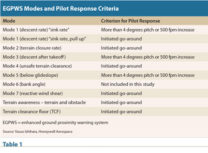
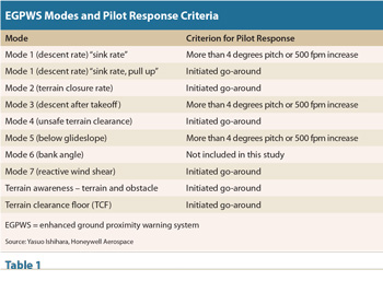
Yasuo Ishihara of Honeywell Aerospace, which designed and manufactures the EGPWS, presented a paper analyzing flight history data recorded by the EGPWS in more than 18 million flights.1 Recorded data indicate the number of alerts for each EGPWS function — such as mode 1, “excessive descent rate,” mode 2, “excessive terrain closure rate” and mode 4, “unsafe terrain clearance” (Table 1) — and the number of flight segments. The database was designed to help investigate the causes of EGPWS alerts.
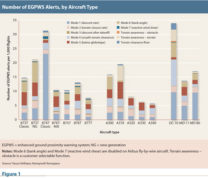
The data also break out the rate of alerts for various transport category aircraft (Figure 1).
“EGPWS records data 20 seconds before and 10 seconds after every EGPWS caution and warning alert in the flight history database,” Ishihara said. “Because the EGPWS flight history data stop 10 seconds after an alert, a pilot response had to start within the recorded time period.”
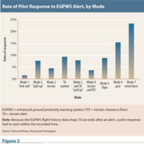
Pilots responded to mode 7, “reactive wind shear,” alerts at the highest rate, followed by mode 4, “unsafe terrain clearance — gear,” meaning landing gear are still retracted when the airplane is near the ground (Figure 2). “It is interesting that the rate of pilots’ response to most EGPWS alerts was very similar whether the alert was ‘terrain, terrain,’ ‘terrain, pull up,’ ‘too low, terrain’ or ‘sink rate, pull up,’” Ishihara said. “Our initial assumption was that a pilot responds to a ‘pull up’ warning at a much higher rate than other alerts.”
Ishihara noted, however, that the EGPWS history data do not indicate the date, time or weather when an EGPWS alert occurred. “Many of the recorded EGPWS alerts might have occurred in day VMC [visual meteorological conditions], in which pilots did not have to respond to the alerts according to the standard operating procedures,” he said.
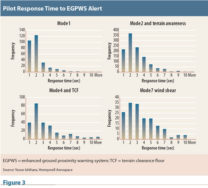
For modes 1, 2, 4 and 7, pilot response time peaked at two seconds in the database (Figure 3). Response was defined as the time it took for the aircraft pitch to increase more than 1.4 degrees after an alert.
“It is also interesting that pilot’s response time was very similar regardless of EGPWS alert types,” Ishihara said. “Our initial assumption was that a pilot would react to ‘terrain, pull up’ and reactive wind shear warnings much sooner than other alerts.”
The analysis looked at aspects of alerts according to the EGPWS mode. Here are some highlights:
Mode 1, “Excessive Descent Rate”
Eighty-nine percent of mode 1 alerts occurred below 500 ft radio altitude, and 67 percent below 200 ft.
“The rate of mode 1 alerts was noticeably high on Boeing 747 classic airplanes,” Ishihara said. “Based on the data analysis, it is believed that the alerts were mostly due to a noisy barometric altitude rate signal provided by the air data computer (inertial vertical speed is not available on 747 classic installations) below 100 ft, in conjunction with a generally higher final approach speed (which requires a higher rate of descent to fly the same approach path) than other airplane types.”
Mode 2, “Excessive Terrain Closure Rate”
The odds of receiving a mode 2 alert depend heavily on the EGPWS software version and whether the airplane is equipped with global positioning system (GPS) and geometric altitude.2
“Ninety-eight percent of mode 2 alerts occurred on airplanes with an EGPWS software version older than -217 (Boeing P/N 965-1690-050 or Airbus P/N 965-1676-001), without GPS or without geometric altitude,” Ishihara said. “In other words, GPS-equipped airplanes with the EGPWS software version newer than -218 and geometric altitude have significantly less risk of activating Mode 2 alerts.”
Mode 3, “Altitude Loss After Takeoff”
Ishihara said, “Almost all mode 3 alerts were occurring during a flight in a traffic pattern such as a training flight. Depending on the traffic pattern altitude and the length of the downwind leg, EGPWS may not switch from the takeoff mode to the approach mode prior to beginning a descent.” Unusual departure procedures, such as the standard instrument departure procedure at one airport in Japan that requires leveling off at 1,000 ft, can cause the alerts if the aircraft overshoots the assigned altitude and must quickly descend.
Mode 4, “Unsafe Terrain Clearance”
Aside from false alerts — 57 percent of mode 4 alerts, mainly because of incorrect radio altimetry or failure of the landing gear switch or the landing flaps switch — unstabilized approaches were a frequent cause.
“When the aircraft was flown at excessive speed on final approach, especially above the flap placard speed, the landing flaps could not be set at 245 ft radio altitude, resulting in ‘too low, flaps’ or ‘too low, terrain’ alerts,” Ishihara said. “There were considerable numbers of ‘too low, gear’ alerts when the landing gear was not down by 500 ft radio altitude during the final approach.” As shown in Figure 2, pilots responded at a higher rate by initiating a go-around for this alert than for other terrain alerts.
Mode 5, “Descent Below Glideslope”
“Thirty-four percent of mode 5 glideslope alerts occurred below 100 ft radio altitude,” Ishihara said. “There were a large number of cases where pilots were ducking under the glideslope below 100 ft. In some other cases, the glideslope signal appeared to become very unreliable below 50 ft. Glideslope alerts occurring at higher altitudes were often triggered while maneuvering to intercept the localizer below 1,000 ft.”
Erroneous mode 5 alerts were identified on some new generation Boeing 737s with integrated approach navigation (IAN) capability.3 Ishihara said, “At some airports, such as Kos, Greece, or Madeira, Portugal, a large number of unwanted glideslope alerts were occurring on IAN-capable [737s]. In all those cases, the aircraft appeared to be on a correct path to the runway threshold; however, the computed glideslope deviation signal provided by the aircraft system was erroneous.”
Mode 6, “Bank Angle Protection”
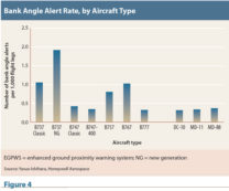
Most maximum bank angles causing alerts in the study period were less than 40 degrees. New generation 737s had the highest rate of alerts, Boeing 777s the lowest rate (Figure 4). In addition, 777s had no alerts for bank angles greater than 45 degrees, while 1.10 percent of other types had alerts for bank angles of 50 degrees, 0.20 percent for 55 degrees, 0.05 percent for 60 degrees, and 0.04 percent for more than 60 degrees. EGPWS recording stops 10 seconds after the “bank angle” alert, so the actual rates of maximum angles might be more than are shown in the database.
Mode 7, “Reactive Wind Shear”
Sixty percent of wind shear alerts occurred during the approach. As seen in Figure 2, mode 7 alerts resulted in the highest percentage of pilot responses.
Causes of Terrain Awareness and TCF Alerts
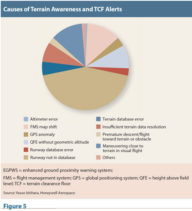
Almost half of terrain awareness and terrain clearance floor (TCF)4 alerts resulted from not having a destination runway in the EGPWS (Figure 5). “This often meant the latest terrain/runway database was not installed,” Ishihara said.
In conclusion, Ishihara said that for maximum effectiveness of EGPWS, operators should update to the latest software; keep the terrain/obstacle/runway database current; install GPS; activate geometric altitude; and select at least one side of the display in the TERR (terrain) mode.
Notes
- Ishihara, Yasuo. “Reviewing Worldwide EGPWS Alert Statistics, Further Reducing the Risk of CFIT.” In Flight Safety Foundation, Proceedings of the 65th annual International Air Safety Symposium, Santiago, Chile. 2012.
- Honeywell describes geometric altitude as “a computed aircraft altitude designed to help ensure optimal operation of the EGPWS terrain awareness and display functions through all phases of flight and atmospheric conditions. Geometric altitude uses an improved pressure altitude calculation, GPS altitude, radio altitude, and terrain and runway elevation data to reduce or eliminate errors potentially induced in corrected barometric altitude by temperature extremes, non-standard altitude conditions and altimeter mis-sets.”
- IAN is an approach option offered by Boeing, which says it is “designed for airlines that want to use ILS [instrument landing system]-like pilot procedures, display features and autopilot control laws for nonprecision (Category I) approaches.”
- A number of CFIT accidents have involved aircraft making final approaches through poor visibility only to strike the ground short of the intended runway. The location of over 30,000 runways at over 12,000 airports is maintained in the EGPWS internal database. The EGPWS maintains a clearance floor spreading outward from each of these runways. If a descent below this clearance floor is detected, the warning ‘too low, terrain’ will be given, regardless of aircraft configuration.”
