Wildlife strikes are a continuing risk in all sectors of aviation. In recent years, the number of reported strikes, particularly bird strikes, has increased along with air traffic, and strike reporting has been emphasized by safety and regulatory organizations. While there is some evidence, particularly in the United States, that the number of damage-inducing strikes has declined, there are other risk factors to consider. For example, the presence of wildlife in an operating environment can cause potentially serious events such as missed approaches and rejected takeoffs. “Regardless of the impact of the animal on the aircraft, the decisions and reactions of the pilot can pose serious risks to flight safety,” according to Gary Searing, executive director of the Bird Strike Association of Canada.
In response to the risks posed by wildlife, hazard management and risk mitigation efforts are evolving, and information technology (IT) is playing an increasing role. “IT systems capture almost everything we do in our jobs. This allows for greater transparency and provides airport wildlife personnel with more efficient and effective data analyses,” says Michael Begier, national coordinator of the Airport Wildlife Hazards Program at the U.S. Department of Agriculture (USDA).
Phil Shaw, managing director of Avisure, an Australia-based firm that specializes in mitigating bird strike risk, adds, “The aviation industry operates under a safety management system (SMS) approach, and this requires documentation and evaluation of hazards and risks and actions taken to mitigate. Having data collection and analysis capability allows for streamlined data capture and robust interrogation.”
The best approach for wildlife hazard management often is to modify habitats to make them less attractive to the primary hazardous wildlife species found in the airport surroundings. Searing says, “In addition, continual, or at least frequent, surveillance of the entire airport is required to monitor hazards and disperse wildlife as necessary to maintain a safe environment for aviation. Many methods are available [and] multiple methods must be used to prevent habituation and airports need to have access to an effective tool for the species of concern and conditions.”
Mogens Hansen, a wildlife biologist working in environmental services and in the aviation industry, suggests that to find solutions to wildlife hazards at airports, a typical risk assessment approach should be maintained, and this requires the following steps:
- Identifying the hazards posed by wildlife;
- Evaluating their probability or measuring the frequency of collision with operating aircraft;
- Looking at the severity of such strikes; and,
- Mitigating the hazards in a priority order, according to the risk posed by the wildlife.
Computer software has not had a significant impact on the way airport wildlife management is accomplished from an operational point of view, but it has changed the way data are collected and analyzed so that some systems automatically collect the data when deterrents are activated, notes Searing.
The areas within the airport perimeter that are most sensitive from a wildlife hazard perspective are those that are attractive to larger birds. “Such areas are most often poorly managed grass areas infested with lot of weeds which give rise to a rich fauna of insects and rodents — the main food items for the most problematic birds at airports. Poorly drained parts of an airfield are very attractive to many birds in the same way. Outside the airport, the most problematic areas are those which give rise to daily feeding movements between a common roosting site and attractive feeding places in the vicinity of the airport in a way leading the birds to cross the flight corridors of aircraft operating at the airport,” says Hansen.
Databases have been developed to provide real-time risk assessment and also to set strategic plans in place based on long-term trends that become evident from regular data capture. “Being able to map hot spots of wildlife activity allows managers to focus on habitat modifications where there will be greatest risk reduction for minimum resource use. Presenting data in graphs and tables as dashboards to management allows easy understanding of big data sets,” explains Shaw.
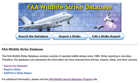
In the United States, one of the major IT innovations has been the development of the National Wildlife Strike Database (NWSD), which has been managed since its inception in 1990 by USDA Wildlife Services through an interagency agreement with the Federal Aviation Administration (FAA).
The NWSD includes more than 208,000 reports of wildlife strikes involving U.S. and foreign civil aircraft operating in the United States. “The overriding focus has been the quality control of data entered for over 90 variables ranging from species and numbers of wildlife struck, location and time of day, phase and height of flight, aircraft type, components struck and damaged, effect of strike on flight, and associated costs,” says Begier. “The attention to detail allows the NWSD to be used in multiple ways to document the nature of the problem temporally and spatially for individual airports and nationwide. The NWSD is used by individual airports and FAA airport certification inspectors to help objectively evaluate and improve wildlife hazard management plans by examining adverse-effect strike rates (the number of strikes causing damage or negative effects on flight, measured per 100,000 aircraft movements) and the species causing those damaging strikes. The NWSD provides opportunities for basic research on topics such as bird migration (height and location of strikes) and bird behavior in relation to aircraft lighting.”
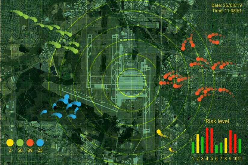
In addition to database management and analysis of wildlife strikes, two other key IT-related developments have been the use of geographic information systems (GIS) to spatially and temporally define wildlife and habitat observations on or near airports; and the refinement and increasing use of bird-detecting radar.
Over the past decade, GIS technology has provided biologists with the ability to spatially document wildlife observations to map areas of increased wildlife activity or hot spots. “This allows airfield managers to quickly see what airfield habitats are attractive to hazardous wildlife. By providing these visualizations, airport biologists can use wildlife survey data to prioritize management recommendations and guide strategies to leverage business decisions,” says Begier.
There also have been a number of advances in the use of bird-detecting radar in the airport environment. “Current research efforts that evaluated these more sophisticated radar units demonstrate that this technology continues to unfold, showing utility in tracking and quantifying wildlife at and around airports. Studies suggest that detection rates are better for large birds, birds flying at high altitudes and birds flying within 2.5 miles [4.0 km] of the radar, suggesting bird-tracking radar can be a useful tool for monitoring flock activity at airports. Currently, these units are used primarily for situational awareness in commercial aviation in the U.S.,” says Begier.
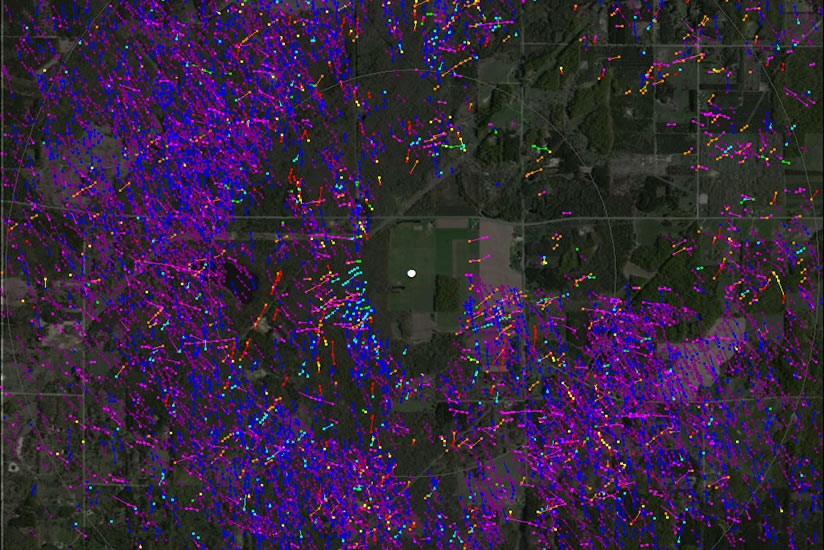
The development of two-dimensional and three-dimensional (2D and 3D) bird radars, together with satellite tracking of birds to which transmitters have been attached, are providing extensive new knowledge of bird movements and bird utilization of the environment. “We also realize by the results obtained that there can be large differences between individuals within the same species in how they move around and utilise the surroundings. Using this new knowledge, we can improve the identification of hazardous situations and areas and give us better ideas on how to solve bird hazards more effectively,” says Hansen.
At some of its facilities, the U.S. Navy integrates radar data into daily air operations using historical radar detection data and real-time observations to avoid pockets of birds in critical airspace, particularly during flight training events. “Using avian radar target counts, the airport wildlife personnel predict peak bird presence by time of day for each month or season. These types of data can be integrated into flight planning by air crews to further inform and add to their decision making, similar to receiving and assessing weather data during preflight activities. Other applications of bird-detecting radar utilized bird target information on a meta-scale to determine the location of attractive habitat areas being used by birds at different times of day. In these situations, bird movements from these areas would initiate at different times of day and then transit critical airspace in the airport environment,” says Begier.
The Role of Training
An important issue in wildlife management is the awareness of the whole airport community (including airline operators) and surrounding land managers of wildlife strike risks. It is important that all stakeholders become involved in reducing the hazard. As a consequence, the importance of training becomes particularly defining.
Training needs to be relevant to the airport and operational personnel. “If the airport has an avian radar, then personnel need to be trained to the level of use that will be made by them of that radar. This is true for any IT component of the wildlife management programme that is employed,” says Searing. “Currently, the largest use of IT are data entry programmes. Personnel must be trained not only on how the software works, but on how to enter data consistently and accurately so that it is of greatest use to managers. Airport managers should be trained to be aware of the options available and about to become available so that they can make informed purchasing decisions and know what potential solutions there are to problems they encounter.”
Shaw adds, “If you expect your staff to be using a specific IT system, you must empower them with the tools to use it effectively. It almost goes without saying, but a level of training that is commensurate with the level of interaction with any given system is imperative — and for most aviation-related service providers legislated via the safety and/or quality management systems. In addition, when employing staff to perform specific duties, a base level of ability must also be ensured. There is no point hiring a data analyst who cannot effectively interpret data, or an aviation biologist who does not understand avian behaviour. At the end of the day, you want your team to be experts in what they do; by hiring skilled professionals and empowering them with formal training and understanding of the IT systems in place, we are extracting maximum efficiency from both our people and systems.”
The Future of IT Solutions
IT solutions will continue to develop over time. “Moreover, the purchase price of hardware and software will hopefully fall further, so that there are no economic barriers for the small airports to use them. The existing IT technology for wildlife management is not just a helping tool. It is creating a real improvement of the safety work in airports to reduce the wildlife strike risk,” says Hansen.
Shaw says that, “given emerging IT system capabilities — with advances like artificial intelligence and predictive analytics — combined with the massive predicted growth of air traffic movements over the next 10 to 20 years (the International Air Transport Association recently predicted a compound annual growth of 3.5 percent per annum, which will result in a doubling of air traffic passengers by 2037), this joint human-machine approach is going to be more important than ever. We believe our experts should be empowered to spend more time on high-value results-based risk management work and less on low-value data entry/extraction tasks.”
IT advances will likely enhance two distinct and critical functions in the domain of wildlife hazard management: collaboration and risk management.
With regard to collaboration, the airport operator traditionally has been responsible for wildlife hazard management, but that is changing. “Whilst airfield operators are still required to take the necessary actions to identify, manage and mitigate the risk to aircraft operations posed by wildlife, the responsibilities are now widening,” says Shaw. “Alliances that are ultimately deemed successful involve collaboration, and new value is created. Expanded interdisciplinary collaboration between all stakeholders (airline, air traffic control, regulator and insurer) will be crucial to ensure that the individual goals of all participants have the opportunity to align with those of the aerodrome’s wildlife management. Whilst emerging technologies hold promise for improving outcomes, it must be remembered that they, just like their human creators, are not error free. It is necessary to evaluate and implement them with a critical eye, keeping in mind their limitations and educating policymakers to do the same.”
In relation to widespread collaboration, safety data need to be shared across multiple institutions and potentially across nations. “[The] data also need to be anonymized and deidentified, and informed consent processes need to include the possibility of a wide distribution. Cybersecurity processes will be increasingly important for addressing the risks of inappropriate use of datasets, inaccurate or inappropriate disclosures, and limitations in de-identification techniques,” says Shaw.
It is important for the IT wildlife hazard management solutions to further strengthen the principles of risk management the way these are supported in the International Civil Aviation Organization’s Global Aviation Safety Plan (GASP), which outlines the coordination and collaboration among international, regional and national safety initiatives to deliver a safe international civil aviation system. “As states build upon these safety management practices within theirs state safety plans (SSPs) to develop advanced safety oversight systems, these structures will also include predictive risk management. Safety analysis will be integrated into all aspects of future wildlife management systems and be used to predict risks prior to the implementation of operational changes,” says Shaw. “Aviation wildlife hazard management is well positioned to leverage upon proven heuristics found within the financial and actuarial industries and deliver against the GASP’s predictive risk requirements. Perfectly suited to large, structured, information rich data sets, these established and recognised analytical processes will support effective decision making in complex and often opaque situations. When coupled with machine-learning tools based in the cloud, wildlife-centric predictive risk is set to get a whole lot racier.”
Mario Pierobon is a safety management consultant and content producer.
Featured image: Susan Reed; base satellite image, © Google Earth
FAA Wildlife Strike Database: U.S. Federal Aviation Administration
Example of avian radar data: U.S. Fish and Wildlife Service
Data exchange icon: © master_art | VectorStock
