Innovations that assist pilots’ visual perception and situational awareness during approach and landing may arrive sooner than some aviation safety specialists anticipate. Subject matter experts told the FSF 68th annual International Air Safety Summit (IASS) in November that promising examples of near-term advances include providing flight crews and air traffic controllers with unprecedented ability to accurately anticipate braking action; making simultaneous approaches to parallel runways more accurate and resilient to avionics faults and human errors; and combining precise navigation with equivalent-vision technology to reduce uncertainties in dispatching and landing airplanes in low-visibility conditions.
Accurate Braking Action
The aviation community has long needed near-real-time runway condition reporting, said Logan Jones, an aircraft performance engineer at Airbus. What now makes this feasible is equipping airplanes with braking-action sensors and automatic capability to communicate via ground server/network with the airport, air traffic control (ATC) and flight crews subsequently arriving at the same runway, he said.
“We often know, more or less, what is on the runway. So the question we’re trying to solve at Airbus is ‘Exactly how slippery [is] the runway … for this aircraft?’” Jones said. “[For line pilots, testing braking after landing is] not so easy in an aircraft. By the time you’re actually down [on] the runway, and you pump the brakes and note how slippery it is, you’re already committed to stop,” said copresenter Nicolas Daveau, also an Airbus aircraft performance engineer.
Jones said that uncertainties about braking performance persist among some airline pilots (ASW, 11/14, ASW, 11/12) years after the work of the U.S. Federal Aviation Administration’s (FAA’s) 2008 Takeoff and Landing Performance Assessment (TALPA) Aviation Rulemaking Committee (ARC).
“The [TALPA ARC Runway Condition Assessment Matrix]1 aims at creating a common language between the airports, the pilots and the airplane manufacturers” by reducing runway conditions to six categories, he said.
Daveau said the success of the TALPA ARC consensus inspired related research and development at Airbus. “We launched a project named CORSAIR [in 2010], standing for contaminated runway state automatic identification and reporting,” he said. CORSAIR described how runway slipperiness information can be collected during the landing, processed after the landing and then transmitted to the ground and to following aircraft crews. The braking action measured during actual landings is independent of any details about the contaminant.
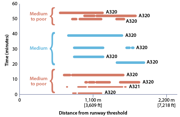
Since November 2013, under a contract with the FAA, CORSAIR has focused on data-mining runway friction condition in real time based on data obtained from airplanes during landing rollout, field-trial demonstrations of the operational concept, and impact on flight operations. One data sample showed 11 flights in a one-hour period in December 2013 at a large hub airport where the runway used was reported as contaminated with 2 mm (0.08 in) of wet snow and the corresponding aviation routine meteorological report described a heavy shower of snow (Figure 1).
Figure 1 — Airbus CORSAIR Braking Action Plots From Airplane Sensors

CORSAIR = contaminated runway state automatic identification and reporting
Notes: Braking action data from sensors on 11 Airbus airplanes show variations in landing distances on the same hub-airport runway in a 60-minute period. The corresponding aviation routine meteorological report showed 2 mm (0.08 in) of wet snow and a heavy shower of snow.
Source: Airbus
For the first 15 minutes, the stopping-distance plot shows a single line representing each of four flights. The length of each line “represents the most degraded areas detected by CORSAIR and the color of the bar, as a result, [represents] the average braking action computed by CORSAIR. So if we look at the four next flights, [the medium to poor runway condition] turned into ‘medium.’ The last [three] flights were ‘medium to poor’… but you don’t really know how these 2 mm of wet snow behaved.”
Logan said CORSAIR should not be considered a substitute for existing methods. One of its limitations is that the aircraft sensors yield no data on runway slipperiness between the threshold and the touchdown point. Similarly, no data about slipperiness are recorded beyond the point where braking ends before the runway end, or while exiting onto a taxiway. Moreover, future system effectiveness would depend on standardization agreements among aircraft and avionics manufacturers and on the participation of sufficient aircraft.
“Our vision for CORSAIR is that we will have data coming from the aircraft, and [that every two minutes, the data would] complement the runway sensors, the runway inspection, the weather reports, the friction testing, the PIREPS [pilot reports],” Jones said. “The airport can [ask,] ‘Is [the runway] getting slippery enough that it’s time to close it, it’s time to clean it, it’s time to do something [else]? Incoming pilots also know exactly what’s going on on the runway.”
Another focus is protecting air carriers from unauthorized uses of their transmitted flight data. Jones said, “TALPA [provides the] common language. … We can’t have Company A reporting slipperiness on a scale of 0 to 100 [while] Company B is reporting slipperiness on a three-point scale.” The Airbus Runway Overrun Prevention System, originally certified only for wet and dry runways, also has benefited from CORSAIR research.
Reduced-Separation Parallels
Required navigation performance (RNP) offers significant advantages for enhancing the safety of simultaneous approach operations to parallel runways. Applying the International Civil Aviation Organization’s (ICAO’s) RNP–Authorization Required (RNP-AR) technical performance standard to design RNP-Established (RNPe) parallel approaches, in particular, offers levels of accuracy and integrity that help create a risk-resilient system, said a subject matter expert from The Boeing Co.
Sheila Conway, technical fellow, project manager and principal investigator in air traffic management operations development, said the navigation precision is equivalent to what operators already rely upon from RNP. In other phases of flight, they “fly against 100 percent threats right now” of collision with an obscured mountain or other terrain, she said, adding, “What we’re suggesting is that we can take the same integrity and accuracy that allow us to do that against terrain, and do that in a traffic environment.
“[RNP-AR has] been on the books in the PBN [performance-based navigation] manual2 to be used for [air] traffic separation, but there really haven’t been the standards to support this. [We] are starting to see it used in oceanic routes, etc. but — as far as reducing separation and making it more efficient — those benefits haven’t really been seen yet.” RNPe approaches are one of the first implementations of RNP-AR for reducing separation, Conway said, crediting joint work by Airbus, Boeing and the FAA on a project that introduced this technology at Seattle-Tacoma International Airport.
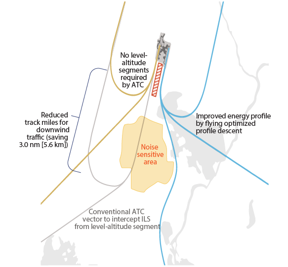
For simultaneous approaches in instrument meteorological conditions to parallel runways, air traffic controllers in the United States apply a set of rules for vertical separation between the aircraft that is trailing and the aircraft that is in front. She said, “That’s often done at a major airport with what we call a ‘high side’ and a ‘low side,’” which refer to ATC clearance limits specifying 1,000 ft of vertical separation between airplanes on opposite sides of the airport (Figure 2). However, this practice adds about 3.0 nm to the downwind track of each aircraft.
Figure 2 — Advantages of Required Navigation Performance–Established Parallel Approach Procedures

ATC = air traffic control; ILS = instrument landing system; RNPe = required navigation performance–established
Notes: The ILS approach crosses a noise-sensitive area, involves longer flight time, and requires 1,000-ft vertical separation between aircraft landing on parallel runways. Precise curved RNPe approaches overcome these disadvantages and enable safe reduction of standard radar traffic separation.
Source: The Boeing Co.
Conway said, “What we’re really trying to resolve then are the long finals, the long downwinds that are created, and this high fuel burn and noise for the community. … As we started to apply RNP in this [situation], we were very much concerned about safety. [With RNPe parallel approaches,] we are advocating flying aircraft closer together and removing this 1,000-ft restriction.
“When we’re running independent operations — the aircraft [crews] not relying on each other’s position — we have a non-transgression zone and a monitor-alert position,” she said. In practice, each aircraft crew acquires the instrument landing system (ILS) localizer and glideslope, and becomes established on “the parallel segment of a non-transgression zone in which the monitoring alert, an extra pilot-controller communication frequency and other safeguards are invoked,” she said.
Her review of U.S. pilot and controller self-reported safety concerns and incidents, however, found that most occurred during their set-up for the parallel segment, prior to where the special monitoring and communication began. The pilot and controller safety concerns tended to involve a misunderstood clearance or procedural errors. Conway said, “As we started to build [RNPe approaches with RNP-AR] transitions to take [flight crews] from top of descent all the way down to the runway, [we realized] many of those issues are mitigated by the early communications and the consistency provided by having a fully closed path to the runway.”
RNP-AR standards enable designers to use curved segments, segmented verticals and other procedure-design options from the PBN manual. “No changes to the actual requirements for the aircraft or to the [pilots’] performance of individual procedures [are necessary; rather this is about] pairs of procedures and how they would operate at a busy airport … depending on what your safety assessment says you need to do,” she said.
Despite the ICAO standards, some reluctance to implement PBN-AR approaches has been encountered by organizations considering them, she said. “It’s really a notion of getting the concepts of integrity and resiliency approved by regulators such that we can expand this out to other areas where PBN could be useful,” Conway said. “The biggest hazard is going to be deviating from the path that the controller [expects] and you expect to fly as a pilot. In the PBN world … we try to avoid the hazard in the first place. Cross-checks of instruments, database management, training, etc. … get you to the point where you’re never in that hazardous state.”
Avionics designers mitigate risks related to sources of errors, problems of navigation systems availability, level of functional integrity expected/required for certification, and how flight crews and ATC mitigate even the rarest situations, such as if both aircraft experience avionics faults, she said.
Conway urged airlines, airports and ATC facilities considering RNP-AR and RNPe approach procedures to parallel runways to anticipate a surprising, counterintuitive aspect. Non-safety-critical (or “nuisance”) resolution advisories (RAs) from traffic-alert and collision avoidance systems (TCAS) may increase significantly at first. When parallel runways are relatively far apart, “the [TCAS logic] geometry actually allows more closure at farther distances, so you have an event for longer, and you hit the [RA] criteria for longer. … That’s not to say that it’s impossible to design them out, but it just needs to be looked at carefully,” she said.
Low-Vision Operations
Enhanced low-vision operations using equivalent-vision systems are still a “very futuristic technology” but worth understanding now, said Ken Elliott, technical director, Jetcraft Corp. They are the leading edge of several approach innovations that will have a significant role in 4D (four-dimensional) airspace management “where everything is time-speed–based — not so much distance-based — to ensure that aircraft are positioned correctly at the right point in space with proper flow management for spacing,” he said.
Several technologies will combine assisted human perception of the real world (such as wearable and non-wearable head-up display systems) with computer-generated virtual reality to create a real-time “VFR-like” (visual flight rules–like) perception of the approach and landing. The virtual reality aspect requires high-precision aircraft-position data.
“We want to use precise navigation and equivalent-vision tools,” Elliott said. “The navigation part is your instrument [segment] of the approach, and the equivalent visual tools fall somewhat into the visual, or the natural vision, segment of the approach.”
Category III (CAT III), the most advanced of legacy approaches, has landing minimums as low as a 50-ft decision height and 600-ft (183-m) runway visual range (RVR) by special authorization from the civil aviation authority, he said.
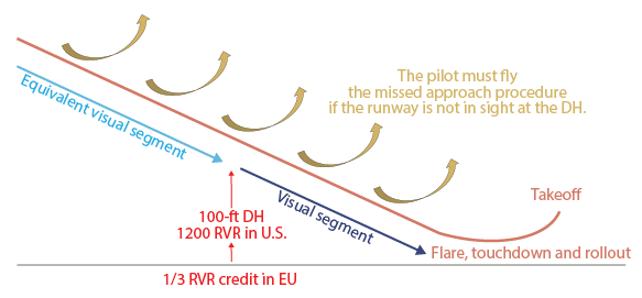
“CAT III is [now] the lowest you’re ever going to get. … You’ve got to be certified, you’ve got to be equipped … and the runway where you’re going to [land] has to be certified and equipped for [CAT III] on a continual basis,” Elliott said. “Today’s PBN approaches have an instrument segment, but no PBN approach will ever get you past a 200-ft decision altitude [and 2400 RVR].” The newest approaches he discussed add an equivalent-vision segment that at first will not lead the flight crew all the way to the runway surface (Figure 3).
Figure 3 — Current Enhanced Flight Vision System (EFVS) Technology

1/3 RVR = one-third reduction in RVR minimums required to attempt an approach with EFVS; DH = decision height (FAA regulations only); EU = European Union (European Aviation Safety Agency regulations); FAA = U.S. Federal Aviation Administration; RVR = runway visual range
Notes: Current EFVS technology provides an equivalent visual segment that bridges the instrument segment and the visual segment. U.S. and European EFVS-qualified pilots who see the runway environment during the instrument segment can continue to descend on the equivalent visual segment to the decision height or RVR minimums shown.
Source: Jetcraft Corp.
In the near term, the equivalent-vision segment will enable pilots to fly beyond the PBN instrument segment’s decision altitude to a 100-ft decision height and 1200 RVR, beyond which pilots will fly a visual segment for the flare, touchdown and rollout. The transition point from instrument flight to equivalent-vision flight will be adjusted closer to the threshold over time, Elliott said.
“For a long time to come, there’s still going to be that [last] natural vision segment, but the goal is to get … down to the ground,” he said, adding that his presentation pertains only to low visibility, not to other reasons why a flight crew would decide to go around. As noted, current PBN approaches will have to be upgraded to exploit equivalent-vision technology. The objective will be enabling airlines to always dispatch flights regardless of forecast visibility at the destination.
“You want to always be able to get in, [to] have predictability and so on with regard to your flights,” he said. That will begin to be feasible with technologies such as the ground-based augmentation system (GBAS) for the global positioning system (GPS), in which GBAS Approach Service Type D (GAST-D) will be equivalent to CAT III minimums. Some airlines already have GBAS equipage, anticipating this capability.
Elliott advised IASS attendees to follow developments related to PBN enhancements, such as the enhanced flight vision system (EFVS), with opaque scene–busting technology based on infrared multi-spectral cameras and millimeter-wave imaging; the synthetic vision guidance system; GBAS; multi-mode receivers for satellite navigation; the airport surface movement guidance control system capabilities for aircraft equipped with automatic dependent surveillance–broadcast In; infrared-based GPS imagery; enhanced distance-measuring equipment; and high-precision navigation satellites.
“GBAS [now] is equivalent, more or less, to an ILS but with a single ground facility at each airport to augment the GPS signal and make it more accurate for landing aircraft at any of the runways at that airport,” he said. There are already 24 airports worldwide using GBAS, including four GAST-C (CAT I-equivalent minimums) airport sites in the United States.
A notice of proposed rulemaking updating U.S. Federal Aviation Regulations Part 91.175, “Takeoff and landing under IFR [instrument flight rules],” Sections “l” and “m,” for which a final rule was pending as of January, “will get [pilots] to 100-ft [above touchdown] and 1200 RVR by using EFVS in lieu of natural vision to descend below decision height/decision altitude on the instrument segment. … Future approaches may have airborne equipage to navigate and see in order to continue to touchdown and rollout. That’s a profound statement. … EFVS [is] the first major change to approach to land, touchdown and rollout since ILS and autoland. That’s a huge change to the whole way we operate and think.”
Notes
- Subbotin, Nicholas; Gardner, Susan. Performance Assessment: Validation Effort of the Runway Condition Assessment Matrix. U.S. Department of Transportation, FAA. Technical Report no. DOT/FAA/TC-TN13/22, June 2013.
- ICAO. Performance-Based Navigation (PBN) Manual. Doc 9613. Third Edition, 2008.
Featured image: © germina | Vectorstock